Donnie Creek wildfire continues to grow
The Donnie Creek wildfire continues to grow and is approximately 572,287 hectares, due in part to the storms in the area.
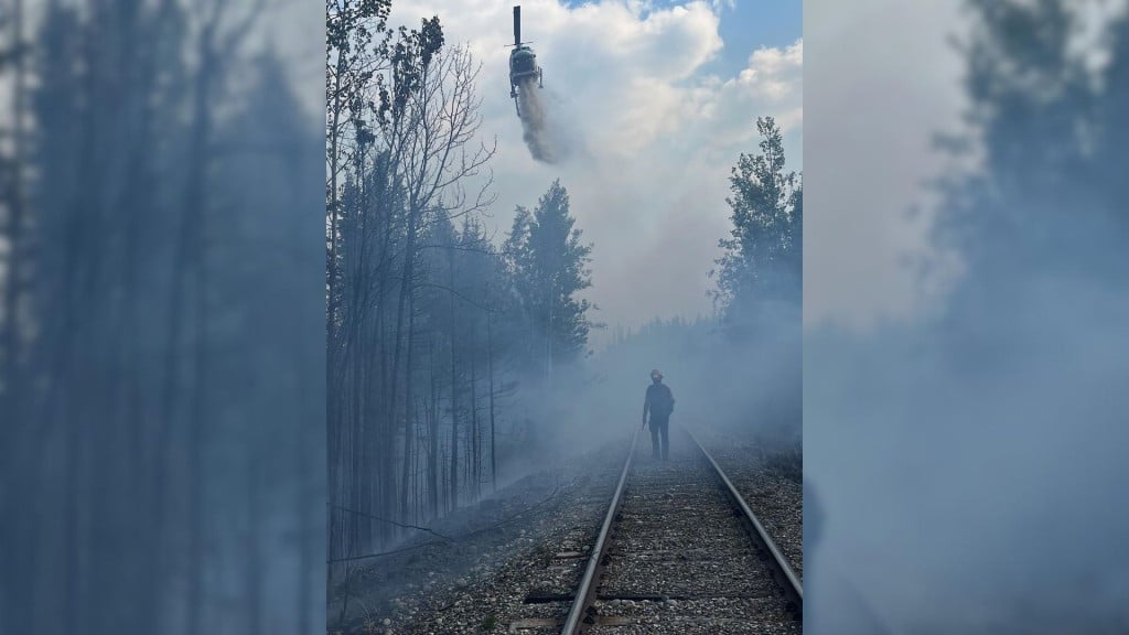
FORT ST. JOHN, B.C. — The Donnie Creek wildfire continues to grow and is approximately 572,287 hectares, due in part to the storms in the area.
The Donnie Creek wildfire is part of the Donnie Creek Complex, which also includes the Muskwa River, Klua Lakes and Zaremba Creek wildfires.
Shaelee Stearns, fire information officer on the Donnie Creek Complex, said parts of the Donnie Creek wildfire experienced some precipitation with the thunderstorms on Wednesday — while other parts of the fire saw increased fire activity due to the heat and the winds.
Local News Straight
to Your Phone
Download our app today!
Available on Android and iOS devices
Crews are expecting Thursday to be a mix of sun and cloud, with a risk of thunderstorms in the morning and a high of 26 degrees Celsius. Environment Canada issued a heat warning for the Fort Nelson area on Thursday.
Environment Canada also recently reissued a special air quality statement for Fort Nelson and the North Peace region. The air quality is at a high risk in Fort St. John.
“With this weather, that means our firefighters will monitor the winds that they are experiencing on the fire line and action the fire appropriately based on the fire behaviour they are seeing,” Stearns said.
On Thursday, 104 firefighters, 18 operations field staff, nine helicopters, 23 pieces of heavy equipment and 12 structure protection personnel are assigned to the fire.
Latest Stories
The Peace River Regional District rescinded evacuation orders for the Donnie Creek wildfire on June 18th, but some evacuation alerts remain in place. An area restriction is also still in place around the wildfire.
The Zaremba Creek fire is approximately 5,790 hectares, the Muskwa River wildfire is classified as being held and remains at about 20,292 hectares, and the Klua Lakes wildfire is out of control at around 40,061 hectares.
The Tooga Creek wildfire is about 36,445 hectares, and an evacuation alert remains for the area.
The West Kiskatinaw River wildfire is classified as being held at 25,095 hectares, and the Peavine Creek wildfire is under control at 4,427 hectares.
The area restriction around the South Peace Complex was rescinded as of noon on July 6th.
There are 31 active wildfires in the Prince George Fire Centre.
The latest information on air quality can be found on the Government of Canada’s website.
For the latest information on evacuation orders and alerts, visit the Peace River Regional District’s, Tumbler Ridge’s and Northern Rockies Regional Municipality’s websites.
For the latest wildfire information, visit BCWS’ website.
Stay connected with local news
Make us your
home page
Authors

Related Articles
Fort St. John and Hudson’s Hope to observe Day of Mourning
Fort St. John and Hudson’s Hope will both observe the Day of Mourning to honour fallen B.C. workers on April 28th.

‘Absolute betrayal’: First Nations blast Eby in leaked transcript of DRIPA meeting
A leaked transcript of a meeting between Indigenous leaders and British Columbia Premier David Eby, about his plan to suspend the province’s Declaration on the Rights of Indigenous Peoples Act,…

Award-winning Indigenous activist to be keynote speaker at Spark conference
Ashley Callingbull is an actress, model and First Nations activist who will make a keynote appearance at the Spark Women’s Leadership Conference in Fort St. John in 2026.
