Work, thunderstorms continue on Donnie Creek wildfire
Work continues on the Donnie Creek Complex as thunderstorms move through the region.
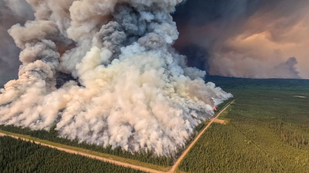
FORT ST. JOHN, B.C. — Work continues on the Donnie Creek Complex as thunderstorms move through the region.
The Donnie Creek Complex consists of the Donnie Creek, Klua Lakes, Muskwa River, Zaremba Creek and Fontas River wildfires, as well as a fire located approximately 135 kilometres north of Fort St. John.
According to BC Wildfire Service (BCWS), crews expect a mix of sun and clouds with scattered showers or thunderstorms over parts of the complex on Tuesday.
Local News Straight
to Your Phone
Download our app today!
Available on Android and iOS devices
Fort Nelson and the North Peace region are currently under a severe thunderstorm watch from Environment Canada.
The Donnie Creek wildfire remains out of control at 580,313 hectares.
Throughout the day on Tuesday, crews will be concentrating their efforts on the fire’s southwest and south flanks.
Crews are working off Tommy Lakes, North Nig and Beatton River Airport Roads to support future ignitions.
Latest Stories
Crews also continue to support machine operations along Jedney Road.
Structure protection personnel are working in the Hunter Lakes area and bridge structures along the Murphy Elm and Fontas Road, according to BCWS. Structure protection is also working along the Beatton River Road.
The Peace River Regional District rescinded evacuation orders for the Donnie Creek wildfire on June 18th, but some evacuation alerts remain in place. An area restriction is also still in place around the wildfire.
The Muskwa River wildfire is being held at 21,056 hectares; the Klua Lakes wildfire grew to 42,892 hectares; the Zaremba Creek wildfire grew to 13,152 hectares; the Fontas River wildfire is now 17,128 hectares, and the fire 135 kilometres north of Fort St. John is 770 hectares.
The Tooga Creek wildfire is still around 36,445 hectares, and an evacuation alert remains in place for the area.
The West Kiskatinaw River wildfire is classified as being held at 25,095 hectares, and the Peavine Creek wildfire is under control at 4,427 hectares.
The area restriction around the South Peace Complex was rescinded on July 6th.
The wildfire discovered on July 5th, nine miles east of 845, grew to 1,372 hectares. The Kotcho Lake wildfire, which was discovered on June 29th, grew to 4,400 hectares.
There are 38 active wildfires in the Prince George Fire Centre.
As of Monday, all campfires have been banned across the province except on the North Coast island of Haida Gwaii.
The ban applies to the Category 1 campfires, measuring up to 50 centimetres by 50 centimetres, expanding prohibitions already applied to certain regions in B.C. or to larger fires.
Cliff Chapman, BC Wildfire Service spokesman, said 160 firefighters from Mexico and the United States were in B.C. helping battle fires in the northeast, with another 100 firefighters from Mexico expected next week.
In addition to Mexican and American firefighters in B.C., there are 100 South Korean firefighters in Quebec, firefighters from France and the Dominican Republic are in the eastern provinces, and firefighters from South Africa have been in Alberta.
The Emergency Management Ministry said low precipitation over the past year had worsened drought conditions in B.C., with most water basins now at level four. Level-four drought involves extremely dry conditions, with adverse effects of socioeconomic conditions and ecosystems likely.
Environment Canada reissued a special air quality statement on June 20th for Fort Nelson and the North Peace region. The air quality is at a high risk in Fort St. John in areas with smoke.
The latest information on air quality can be found on the Government of Canada’s website.
For the latest information on evacuation orders and alerts, visit the Peace River Regional District’s, Tumbler Ridge’s and Northern Rockies Regional Municipality’s websites.
For the latest wildfire information, visit BCWS’ website.
With files from Canadian Press
Stay connected with local news
Make us your
home page
Authors

Related Articles
Northeast B.C. communities to be given $86,000 for firefighting equipment
Tumbler Ridge, Pouce Coupe and the Northern Rockies Regional Municipality are the communities in northeast B.C. to receive funding for firefighting equipment from the Ministry of Emergency Management and Climate Readiness.
Wildfire training sessions to help northeast B.C. avoid ‘dangerous positions’
North America Fire Rescue is set to host wildfire training sessions in Chetwynd and Fort St. John this spring.
BC Wildfire Service readies for 2026 season with record 2,400 firefighter applications and more equipment in Prince George depot
The BC Wildfire Service has received around 2,400 firefighter applications and improved its equipment depot in Prince George in preparation for the wildfire season 2026, it said in a press release.
