Rising temperatures increase fire behaviour around Donnie Creek wildfire
The Donnie Creek wildfire remains classified as out of control while rising temperatures are causing an increase in fire behaviour.
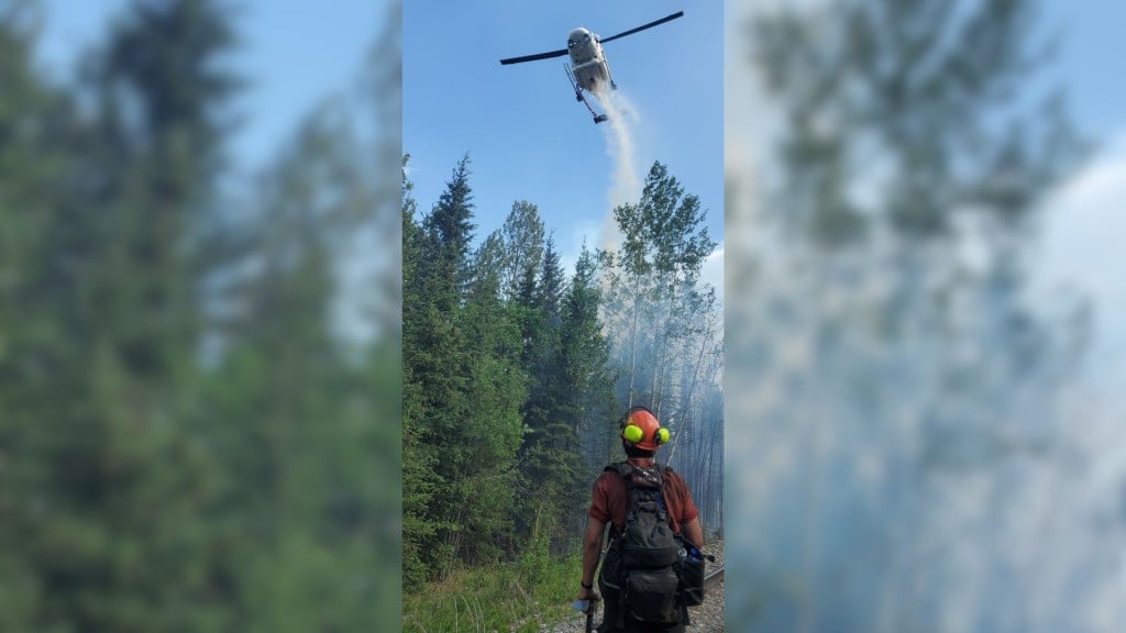
FORT ST. JOHN, B.C. — The Donnie Creek wildfire remains classified as out of control while rising temperatures are causing an increase in fire behaviour in the area.
The Donnie Creek wildfire is part of the Donnie Creek Complex along with the Muskwa River, Klua Lakes and Zaremba Creek wildfires.
Nicole Bonnet, fire information officer of the Donnie Creek Complex, said the increased temperatures will cause a warming and drying trend.
Looking for something to do?
Check out our new Events Calendar!

“Which means the places where the fire is burning more actively or intensely already will start to pick up in fire activity,” Bonnet said.
“Those areas are well within the fire perimeter itself as it exists right now.”
Because of this, more smoke will likely be visible on the fire in the coming days.
On Tuesday, 109 firefighters, 20 operational field staff, ten helicopters, 21 pieces of heavy equipment, and 12 structure protection personnel are assigned to the Donnie Creek Complex.
Latest Stories
The fire information officer said crews are focusing on the fire’s south flanks. Crews were demobilized from the Trutch area over the weekend.
On June 2nd, a 40 aerial ignition was conducted near Jedney Road as part of a 1,750-hectare planned ignition to bring the fire’s edge to a heavy equipment guard.
A guard is a wide path or dirt road where all fuel is removed and can be achieved by hand or machinery for larger guards, also known as a control line.
Crews continue to mop up and extinguish hot spots within the fire’s perimeter near Tommy Lakes Road and Birley Creek Road.
The Peace River Regional District rescinded evacuation orders for the Donnie Creek wildfire on June 18th, but some evacuation alerts remain in place. An area restriction is also still in place around the wildfire.
The Zaremba Creek grew to about 5,790 hectares, the Muskwa River wildfire is classified as being held and remains at approximately 20,292 hectares, and the Klua Lakes wildfire is out of control at around 40,061 hectares.
The Tooga Creek wildfire is about 36,445 hectares, and an evacuation alert remains for the area.
The South Peace Complex incident management team has been demobilized, and the United States incident management team is on their way home on Tuesday.
The West Kiskatinaw River wildfire is now classified as being held at 25,095 hectares, and the Peavine Creek wildfire is under control at 4,427 hectares.
The wildfire near Inga Lake that started on June 29th and a fire that started north of Odelyn Creek on June 28th have both been extinguished.
A wildfire discovered on June 28th near Fort Nelson is now under control.
The fire near Elleh Creek discovered on June 23rd is now being held at 112 hectares.
There are 29 active wildfires in the Prince George Fire Centre, and the BC Wildfire Service responded to 46 new wildfires over the weekend. Of those fires, 36 are out, under control, or being held.
Environment Canada recently reissued a special air quality statement for Fort Nelson and the North Peace region. The air quality is at a very high risk in Fort St. John in areas with smoke.
The latest information on air quality can be found on the Government of Canada’s website.
For the latest information on evacuation orders and alerts, visit the Peace River Regional District’s, Tumbler Ridge’s and Northern Rockies Regional Municipality’s websites.
For the latest wildfire information, visit BCWS’ website.
Stay connected with local news
Make us your
home page
Authors

Related Articles
District of Taylor to host Community Clean-Up Day
The District of Taylor is hosting its Community Clean-Up Day on May 13th from 9:30 a.m. to 12 p.m. followed by a BBQ lunch.

Artemis II exhibit opens for visitors in Dawson Creek
The SpaceModel Museum in Dawson Creek is currently showcasing a scale model of the recently concluded Artemis II space mission.

Man sentenced to jail for sexual assault charges
A man was sentenced to jail for 135 days after he was found guilty of sexual assault.
