Fire activity expected to increase on record-breaking Donnie Creek wildfire
Fire activity is expected to increase on the record-breaking Donnie Creek wildfire as the region heads towards warmer and drier weather.
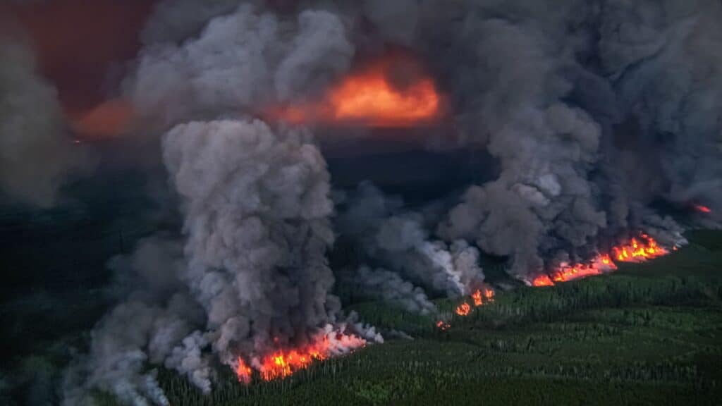
FORT ST. JOHN, B.C. — Fire activity is expected to increase on the record-breaking Donnie Creek wildfire as the region heads towards warmer and drier weather.
The Donnie Creek wildfire is part of the Donnie Creek Complex, which also includes the Muskwa River, Klua Lakes and the Zaremba Creek wildfires.
Nicole Bonnet, fire information officer on the Donnie Creek Complex, said fire activity increased on the Donnie Creek fire’s northwest corner on Monday afternoon. However, the burning area is well within the fire’s perimeter and near an old fire scar.
Storms are forecasted to move through the area, which may bring winds gusting up to 60 kilometres per hour, possibly increasing fire behaviour.
“[The storms] will have some fairly localized impacts just given the size of the fire; what you see on one spot of the fire won’t be what you see on another spot,” Bonnet explained.
“But we’ve got all the aircraft in the air, so we can always monitor and readjust our resources if we need to.”
On Tuesday, 136 firefighters, 17 operational field staff, 16 helicopters, 29 pieces of heavy equipment and 13 structure protection personnel are assigned to the fire.
Latest Stories
Bonnet said fire crews are doing mop-up and patrol from a previously completed machine guard near the Beatton River, moving east towards the Tommy Lakes Road.
Near the 30-kilometre mark on the Tommy Lakes Road, crews will begin building a guard with heavy equipment.
A guard is a wide path or dirt road where all fuel is removed and can be achieved by hand or machinery for larger guards, also known as a control line.
Bonnet said crews are also working off the 123 Road, moving east into the fire’s perimeter to put out hotspots.
The machine guard near Grewotsch Creek was completed Monday, and crews on Tuesday are extending the line.
“Once that’s complete, they’ll be looking at opportunities for small-scale hand ignition to clean up the unburnt fuel between the fire’s edge and the guard,” Bonnet said.
She said danger tree assessors and fallers are also in the area. Danger trees are trees that could fall and cause damage to infrastructure or hurt people.
The Peace River Regional District rescinded evacuation orders for the Donnie Creek wildfire on June 18th, but some evacuation alerts remain in place. An area restriction is also still in place around the wildfire.
The Klua Lakes wildfire is approximately 37,869 hectares, the Muskwa River wildfire is roughly 20,292 hectares, and the Zaremba Creek wildfire is about 212 hectares.
Bonnet said the Alaska Highway is not currently affected by the wildfires but reminded travellers to check DriveBC.ca for the latest information.
The Tooga Creek wildfire is about 36,445 hectares, and an evacuation alert remains for the area.
There are 24 active wildfires in the Prince George Fire Centre.
The special air quality statement issued in northeastern B.C. was reissued on June 20th.
The air quality is currently a high risk in Fort St. John.
For the latest wildfire information, visit BCWS’ website.
Stay connected with local news
Make us your
home page
Authors

Related Articles
Dawson Creek RCMP begin investigation into deadly side-by-side incident
The Dawson Creek RCMP have announced an investigation into a side-by-side incident which left two children dead and three injured.

Local family services organization recipients of $10K Surerus community fund grant
Nenan Dane’s executive director says the organization is “still nailing down” where the funds will go.
(Opinion) Bear Flat Dispatch: Caterpillars, Bears and Poplar Trees
Regular contributor Ken Boon writes about the turning of the seasons in Bear Flat.
