Donnie Creek wildfire about two kilometres from Alaska Highway
The Donnie Creek wildfire is approximately 487,509 hectares and is about two kilometres from the Alaska Highway, according to BC Wildfire Services (BCWS).
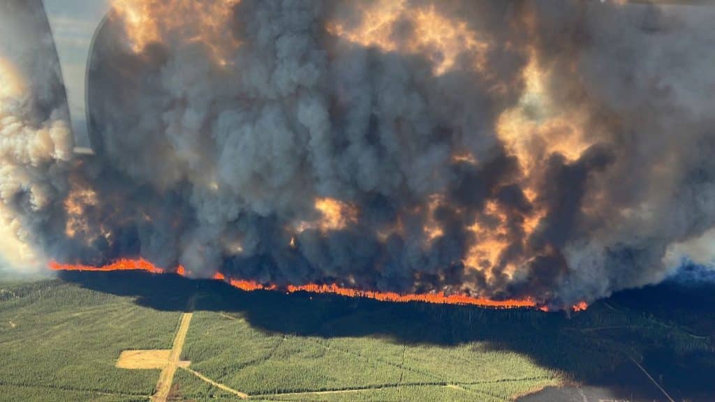
FORT ST. JOHN, B.C. — The Donnie Creek wildfire, part of the Donnie Creek Complex, is approximately 487,509 hectares and is about two kilometres from the Alaska Highway, according to BC Wildfire Services (BCWS).
It’s possible that travel on the highway could be affected in the future, but at this point, the highway remains open. BCWS says the fire is near Trutch, which is located near the Mile 202 rest stop.
Structure protection personnel have been deployed in the area, and crews are prepared to assist traffic control if needed.
Local News Straight
to Your Phone
Download our app today!
Available on Android and iOS devices
Smoke is highly affecting visibility on the Alaska Highway, between Powder King Road and Weiland Road, as well as between Chetwynd and Dawson Creek.
On Tuesday, about 130 personnel, 23 pieces of heavy equipment, and 11 helicopters are working on the fire.
BCWS says northerly winds of about 15 kilometres and gusts of up to 25 kilometres an hour are still pushing the Donnie Creek wildfire south.
Though rain is expected in the Peace and Northern Rockies regions, not much precipitation is anticipated to fall on the fire.
Latest Stories
Despite the rain missing the Donnie Creek Complex, BCWS is seeing cooler temperatures and higher relative humidity, which should help crews and decrease fire behaviour.
The Peace River Regional District issued new evacuation alerts and orders for the Donnie Creek wildfire. An area restriction is also still in place.
The Klua Lakes wildfire and the Muskwa River wildfire, also part of the Donnie Creek Complex, haven’t shown much growth but remain out of control.
The Tooga Creek wildfire grew to approximately 31,000 hectares, and an evacuation alert remains in place.
For the latest evacuation order and alert information, visit the Peace River Regional District’s and Northern Rockies Regional Municipality’s websites.
For the latest information on road closures, visit DriveBC.
There are approximately 33 active wildfires in the Prince George Fire Centre.
For the latest wildfire information, visit BCWS’ website.
Stay connected with local news
Make us your
home page
Authors

Related Articles

Northern Health warns of two new measles exposures in Fort St. John
Northern Health is warning residents in Fort St. John of two potential measles exposures on March 17th.
Applications open for Tumbler Ridge Scholarship Program
The District of Tumbler is asking for applications for its 2026 scholarship program. The deadline to apply is May 15th.

Peace Fibre Fest to return in 2026 for yarn enthusiasts
The Peace Fibre Fest began in 2019 when its founders wanted to being a yarn arts extravaganza to the Peace region.
