UPDATE: Increased wildfire activity at Donnie Creek Complex causes new evacuation orders and alert
The Peace River Regional District has issued a new evacuation order and alert for the Donnie Creek/Tommy Lakes wildfires. The Northern Rockies Regional Municipality has also upgraded an evacuation alert to an order.
UPDATE: The Northern Rockies Regional Municipality has updated the map to show the correct boundaries of areas under an evacuation order as of May 29th at 3 p.m.
* May 29th, 2023 1500 hrs. Map and boundaries updated to reflect correct area.
— NRRM (@NorthernRockies) May 29, 2023
⚠️ EVACUATION ORDER FOR THE KLUA LAKES AREA
May 28, 2023 at 1000 hrs
Pursuant to Section 12 (1) of the Emergency Program Act the current Evacuation Alert area is being elevated to an Evacuation Order pic.twitter.com/6vL7MNNDEo
FORT ST. JOHN, B.C. – The Peace River Regional District has issued a new evacuation order and alert for the Donnie Creek/Tommy Lakes wildfires. The Northern Rockies Regional Municipality has also upgraded an evacuation alert to an order.
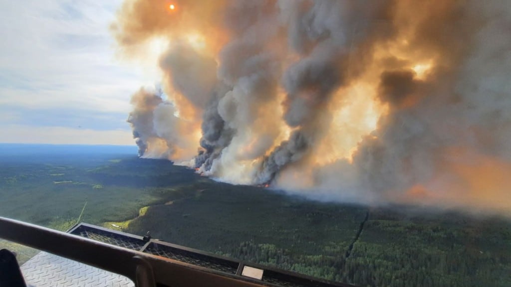
The B.C. Wildfire Service recommended the changes after increased fire activity this weekend. Warmer weather and strong winds have driven the increased activity of the fires located 158km north of Fort St. John and 136km south of Fort Nelson.
The Peace River Regional District evacuation order for the Donnie Creek is in effect for the following areas:
- The area North of Grewatsch Creek on PDR 222.
- The area North of km 44 on Tommy Lakes Road.
- The area North of km 20 on PDR 204 (Beatton Airport Road).
- Extending north to the border with the Northern Rockies Regional Municipality.
This Order does not apply to First Nations communities as they issue their own orders and alerts.
Latest Stories
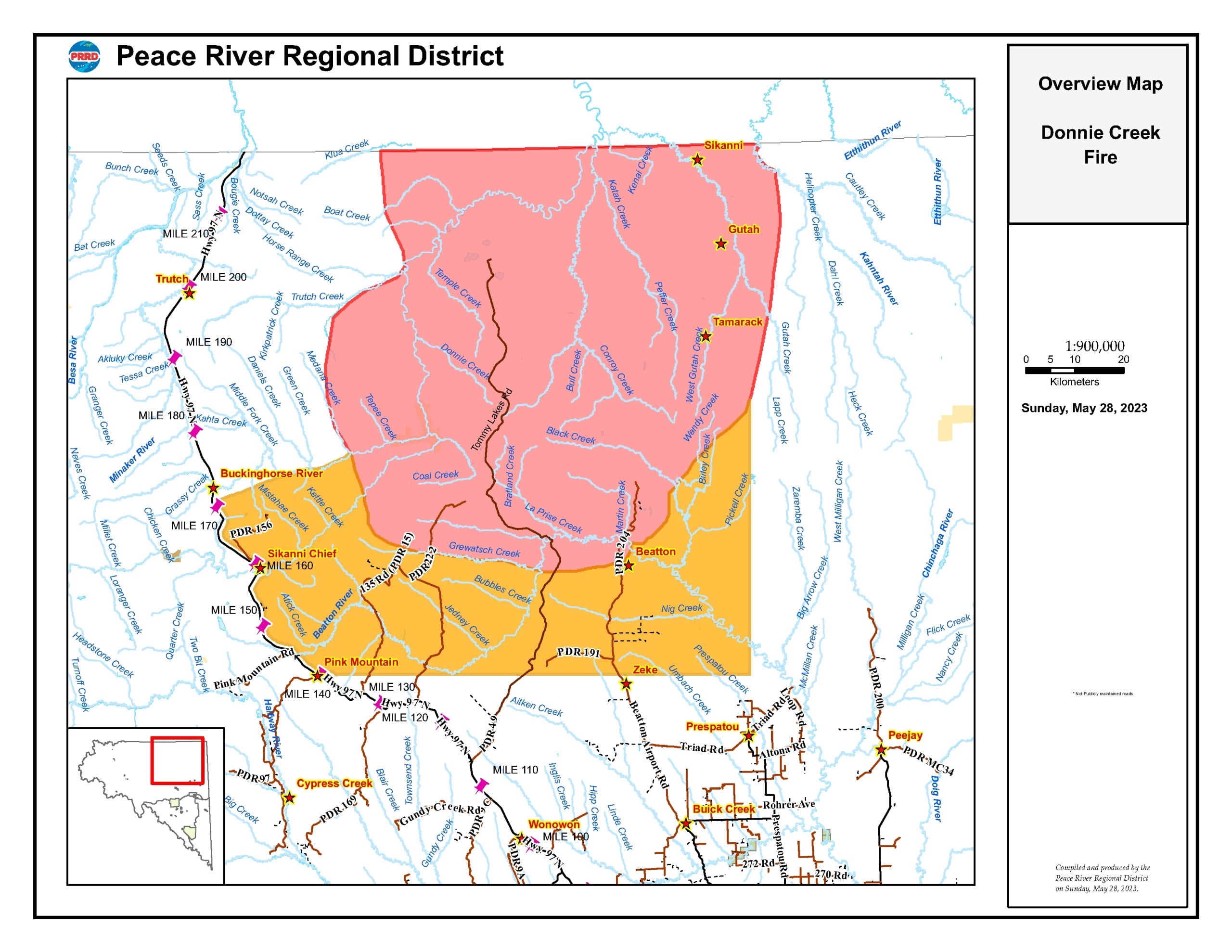
The Northern Rockies Regional Municipality order is in effect for the following general area:

- Bounded on the south by the NRRM/PRRD boundary
- From a point on the west side at longitude 122 16.03W arched up to a northern point at latitude 58 17.52’N
- From a point on the east side at longitude 121 00.45W arched up to a northern point at latitude 58 17.52’N
The Peace River Regional District area that is under an evacuation alert due to the Donnie Creek/Tommy Lakes wildfire includes the following areas:
- 1km East of Highway 97 between km 225 and km 273.
- Extending East 88km from a point 1km East of km 225 on Highway 97, and then extending 56 km North to the boundary of Evacuation Order #4.
- Extending North-East from a point 1km East of km 273 on Highway 97 to the confluence of the Buckinghorse River and Medena Creek, then continuing East along the Southern boundary of Evacuation Order #4.
For those in the evacuation order issued by the Peace River Regional District, you should travel to Fort St. John and the North Peace Arena. You can also call if you need Emergency Support Services (ESS) at 1-800-670-7773.
For those in the area covered by the Northern Rockies Regional Municipality, you should head to Fort Nelson.
North Peace Complex Fires
Columns of smoke are highly visible along Highway 97 due to the Stoddart Creek wildfire. According to the B.C. Wildfire Service current weather conditions have not impacted the wildfires in the North Peace Complex, which includes Stoddart Creek wildfire (G80291).
There is minimal fire activity remaining. However, some smoke may be visible within the fire perimeter until crews have extinguished all remaining hot spots.
Stay connected with local news
Make us your
home page
Authors

Related Articles
Woman and dog die in Alaska Highway crash
Northern Rockies RCMP have reported a single vehicle car crash on the Alaska Highway ended with a woman and her dog dying on June 11th.

Northern Health launches off-road vehicles survey in wake of Pouce Coupe crash
A Northern Health research team is conducting a survey on the use of off-road vehicles in northern B.C.
Fort St. John received two community leadership awards from NCLGA
The City of Fort St. John has received two awards from the North Central Local Government Association.
