Evacuation orders no longer active in northeast B.C.
Around 450 properties remain under alert in the North Peace Complex, according to the PRRD’s EOC Director Mike Watkins.
FORT ST. JOHN, B.C. – The rain received in northeast B.C. this weekend helped alleviate fire behaviour in the region leading to all remaining evacuation orders being lifted.
The Peace River Regional District announced Monday evening that residents impacted by the Stoddart Creek and Donnie Creek wildfires can return home.
The areas are now under an alert to remain prepared in case an evacuation order is implemented again.
The Stoddart Creek wildfire alert is for:
- Properties north of 254 road on both sides of the Alaska Highway to the top of East Cache Creek,
- Properties on the West side of the Alaska Highway and the Mile 98 Road,
- Properties on the West side of Prespatou Road, Whispering Pine Lake and Umbach Creek,
- Properties south of Triad Road and,
- All properties on the Beatton Airport Road from the Alaska Highway to Triad Road.
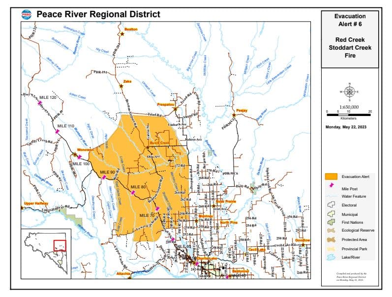
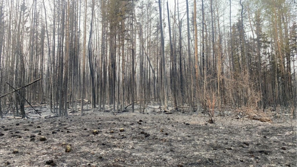
The Stoddart Creek and Red Creek wildfires are now being held, meaning they aren’t believed to grow. The Stoddart Creek fire is approximately 29,327 hectares in size, while the Red Creek fire is 2,947 hectares.
Latest Stories
Around 450 properties remain under alert in the North Peace Complex, said the PRRD’s EOC Director Mike Watkins in a briefing Monday evening.
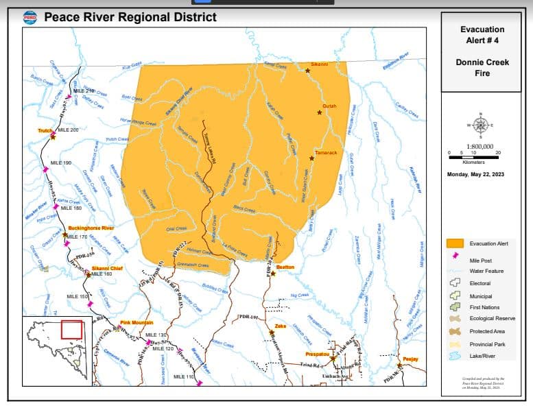
The Donnie Creek wildfire is still considered out of control at 134,769 Hectares, said the BC Wildfire Service.
The order for the wildfire has been rescinded, but an alert remains in place for:
- North of the Beatton River on the Tommy Lakes Road and the Beatton Airport Road,
- North of Grewatsch Creek on PDR 22,
- Extending North to the border with the Northern Rockies Regional Municipality.
Watkins thanked the municipalities, including Fort St. John and Dawson Creek, that took in hundreds of evacuees over the past few weeks.
Environment Canada said 50 to 75 mm of rain is expected in the Peace region from Monday evening through Tuesday, with local amounts approaching 100 mm for southern areas of the PRRD near Fort Nelson.
Stay connected with local news
Make us your
home page
Authors

Related Articles
District of Taylor releases ‘Sunshine List’ for 2025
The District of Taylor has released its ‘Sunshine List’ for 2025, detailing spending of more than $3 million on council and employee salaries and more than $14 million on payments for goods and services.
(UPDATE) RCMP investigating possible human remains found near the city
The RCMP is investigating a report of possible human remains, BC Hydro crew discovered on June 8th near the city.

CVBC holds discipline hearing for Fort St. John veterinarian
The College of Veterinarians of British Columbia held a discipline hearing for Fort St. John veterinarian, Justin Sewell, for misconduct on June 8th.
