Donnie Creek wildfire continues to grow; one evacuation order ends
The Peace River Regional District has rescinded evacuation order #7 for the Donnie Creek wildfire, but the fire continues to grow.
FORT ST. JOHN, B.C. – The Peace River Regional District has rescinded evacuation order #7 for the Donnie Creek wildfire, but the fire continues to grow.
Evacuation order #7 covers the area near Trutch and the Alaska Highway. Residents can now return home. The following areas are affected by this change:
– east of Highway 97N between Mile 192 and Mile 207; and
– extending East 20 km of Highway 97N.
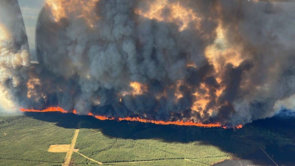
The Donnie Creek wildfire continues to grow, and as of Sunday, it is now estimated to be 534,388 hectares.
The BC Wildfire Service carried out a planned ignition Saturday near Trutch B.C., where the wildfire had burned within 2 kilometres of the Alaska Highway.
The operation consisted of removing a 19 kilometre stretch of forest fuels east of Buckinghorse Road which runs parallel to Highway 97.
Latest Stories
Motorists travelling in the area may see thick columns of smoke and are requested to exercise caution to protect ground crews working along the highway. Visit www.drivebc.ca for the most up-to-date information about Highway 97.
Between the decrease in temperature and increase in humidity and the chance of rain, fire behaviour is expected to be reduced. However, due to the size of this fire, there may be areas that do not receive any precipitation. The decrease in fire behaviour will be short-lived; the fire will become more active next week.
The fire danger rating the North Peace remains high to extreme despite rain being received in various parts of the region in recent days.
This means forest fuels are very dry, and the Donnie Creek wildfire can spread easily, burn vigorously, and challenge fire suppression efforts. Drought conditions persist in much of the Prince George Fire Centre.
Evacuation order #6 still remains in effect and covers the following area:
- 4 km east of Highway 97N between Sikanni Chief and Pink Mountain;
- due east from Pink Mountain to a point where it intersects with West Milligan Creek;
- due North 24 kms; and
- west to point of intersection (Sikanni Chief 4 km east of Highway 97).
Donnie Creek/Tommy Lakes Evacuation Alert #11 remains in place and includes area:
- West of Hwy 97 N at Mile 207 to the Prophet River
- Southwest following the Prophet River for 14km to Milliken Creek
- From that point, travel south maintaining approximately 6 kms buffer west of Hwy 97 N to a point of
- intersection of km 20 on the Pink Mountain Road (Halfway River)
- South following Halfway River to the intersection of Boring Ranch Road and Cypress Creek Road
- Due east to a point of intersection with Highway 97 N at km 177
- Continue due east to the intersection with Beaton Airport Road at km 37
- Continuing due east to the intersection with Prespatou Road at km 30
- To a point approximately 5 km west of Milligan Creek Road
- North approximately 22 km to a point of 1 km west of Milligan Creek Road
- Due west to a point 4 km east of Pink Mountain
- North 4 km east of Highway 97 north to a point of intersection with Sikanni River
- Northeast for 4 ½ km to Mistahae Creek
- Northwest to a point of intersection with Trutch Creek, due east of km 305
- Northwest to Hwy 97 N intersecting Mile 192
- Following the west side of Hwy 97 N to Mile 207
- Northwest to the Prophet River
Click here to see a digital map of all the alerts and orders that remain in place around the Peace River Regional District. For more on the Donnie Creek wildfire, click here.
Stay connected with local news
Make us your
home page
Authors

Related Articles

Indigenous care support worker named Co-op Community Champion
February’s Co-op Community Champion Shara-Lynn Singh, who has Cree and Tahltan Nation ancestry, began her work in Indigenous support care at the Fort St. Hospital a year ago.
OpenAI contacted RCMP about Tumbler Ridge shooter’s ChatGPT account after attack
ChatGPT employees considered alerting authorities about the account connected to the Tumbler Ridge shooter.