Area restriction altered around South Peace Complex wildfires
The BC Wildfire Service (BCWS) is changing the area restriction order for the South Peace Complex fires.
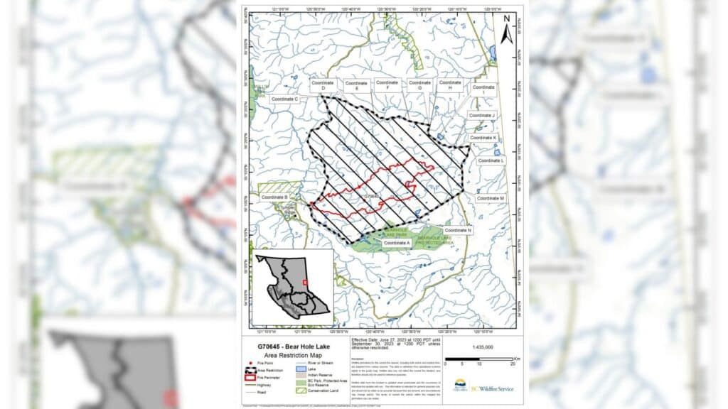
TUMBLER RIDGE, B.C. — The BC Wildfire Service (BCWS) has changed the area restriction order for the South Peace Complex fires.
The South Peace Complex includes the 4,427-hectare Peavine Creek wildfire and the 25,095-hectare West Kiskatinaw River wildfire.
The changed area restriction goes into effect at noon on June 27th and remains in force until September 30th or until rescinded.
Local News Straight
to Your Phone
Download our app today!
Available on Android and iOS devices
The order applies to crown land in the boundaries below:
- Starting on Bear Hole Lake Road just north of Bear Hole Lake at coordinate A (55° 03.912’N, -120° 40.684’W);
- Then heading west along the north ditch line of Bear Hole Lake Road to Highway 52 and Bear Hole Lake Road intersection at coordinate B (55° 09.110’N, -120° 56.077’W);
- Then heading north along Highway 52 to a point 2 km south of the Highway 52 and Skunk Creek Road intersection at coordinate C (55° 26.275′ N, -120° 49.930’W);
- Then heading easterly, passing through points D to L along various roads and rights-of-way to Highway 52 near Twin Lakes to coordinate L (55° 16.507’N, -120° 09.580’W);
- Then heading south along Highway 52 to the point where Highway 52 crosses Borden Creek at coordinate M (55° 09.510’N, -120° 12.682’W);
- Then heading westerly to Kiskatinaw Road at a point just southwest of Blackhawk Lake at coordinate N (55° 05.386’N, -120° 26.372’W);
- Then heading westerly to the starting point at coordinate A (55° 03.912’N, -120° 40.684’W).
No one is allowed in the area unless they have written authorization. Failure to comply may result in a violation ticket for $1,150.
Latest Stories
Sharon Nickel, fire information officer for the South Peace Complex, said the fires in the complex did receive some precipitation recently but are already drying out again.
On Tuesday, 107 wildland firefighters and three pieces of heavy equipment are working on the West Kiskatinaw River wildfire, and 31 firefighters are working on the Peavine Creek wildfire.
Five helicopters are assigned to the South Peace Complex.
A new wildfire that started near Rocket Knife Creek on Monday night is under a hectare and out of control. It is suspected to be caused by lightning.
The fire that started south of Rocky Creek on June 26th is now under control, and the fire near Jackfish Lake has been extinguished.
There are 27 active wildfires in the Prince George Fire Centre.
Environment Canada recently reissued a special air quality statement for Fort Nelson and the Peace region. The air quality is at a high risk in Fort St. John.
The latest information on air quality can be found on the Government of Canada’s website.
For the latest information on evacuation orders and alerts, visit the Peace River Regional District’s, Tumbler Ridge’s and Northern Rockies Regional Municipality’s websites.
For the latest wildfire information, visit BCWS’ website.
Stay connected with local news
Make us your
home page
Authors

Related Articles

New pool to honour Fort St. John businessman in its name and with 20-foot statue
Fort St. John’s new pool is to be named after one of the city’s most recognizable residents, local businessman Trevor Bolin.
Vehicle’s hood destroyed in Highway 97 crash in Fort St. John
Emergency services were reportedly on the scene of a crash on the Alaska Highway in Fort St. John on March 31st.

Tumbler Ridge shooting victim Maya Gebala is out of intensive care: dad
VANCOUVER — The father of Tumbler Ridge, B.C., mass shooting victim Maya Gebala says his daughter has been transferred out of intensive care into a “recovery and rehab-focused unit.” David…
