Changes to evacuation orders, alerts in Peace region
The Peace River Regional District shared several changes to evacuation orders and alerts surrounding the West Kiskatinaw River and Peavine Creek wildfires.
TUMBLER RIDGE, B.C. — The Peace River Regional District shared several changes to evacuation orders and alerts surrounding the West Kiskatinaw River and Peavine Creek wildfires.
Peavine Creek evacuation order #1 has been cancelled. Properties previously under the order are now under Peavine Creek Evacuation Alert #2.
These orders affect the following areas:
Local News Straight
to Your Phone
Download our app today!
Available on Android and iOS devices
- from the intersection of the Gunter Bridge and Highway 52 E, travel east to the B.C. and Alberta border;
- from the B.C. and Alberta border, travel south for 14 kilometres;
- continue west to the Pembina Steeprock Gas Plant;
- continue southwest to approximately kilometre 212 on Highway 52 E;
- continue north along Highway 52 E to about kilometre 214 on Highway 52 E;
- continue west for about 1.5 kilometres, then travel north for approximately 1 kilometre;
- continue due west to the Kiskatinaw River;
- follow the Kiskatinaw River northwest to the One Island Lake Bridge; and
- continue northeast along the south side of One Island Lake Road to Gunter Bridge.
The community of Kelly Lake and other areas listed below are no longer under alert:
- from the B.C. and Alberta border east past kilometre 235 of Highway 52E;
- south to the One Island Lake Bridge;
- northeast along the north side of One Island Lake Road to Gunter Bridge;
- east to the B.C. and Alberta Border;
- north along the B.C. and Alberta border for 22 kilometres;
- from kilometre 212 of Highway 52E south along the east side of the Highway to kilometre 194;
- east to the B.C. and Alberta border;
- north along the B.C. and Alberta border for 21.5 kilometres; and
- east to kilometre 212 of Highway 52E.
Latest Stories
The PRRD has reduced some of evacuation order #4 for the West Kiskatinaw River wildfire.
Areas remaining under evacuation order #4:
- Starting at the intersection of Highway 52 N and N Old Fellers Road, travel east to the One Island Lake bridge;
- Following the Kiskatinaw River southeast to the point of intersection with Cutbank Creek;
- continue east along Cutbank Creek from 1 kilometre;
- continue south for approximately 1 kilometre, then travel east for 1.5 kilometres to Highway 52 E;
- continue south along the west side of Highway 52 E to kilometre 195;
- continue west along the Kiskatinaw River to the district of Tumbler Ridge boundary, including the Kiskatinaw Forest Service Road and Bearhole Lake Road;
- travel north along the district of Tumbler Ridge boundary to kilometre 80 on Highway 52 N; and
- travel north along the east of Highway 52 N to the intersection of Highway 52 N and N Old Fellers Road.
The areas west of Highway 52 N, previously under West Kiskatinaw River Evacuation Order #3, are now under West Kiskatinaw River Evacuation Alert #2.
PRRD said there is also a small area extending south from Cutbank Creek and east to Highway 52 E that was previously under West Kiskatinaw River Evacuation Order #3 that is now under Peavine Creek Evacuation Alert #2.
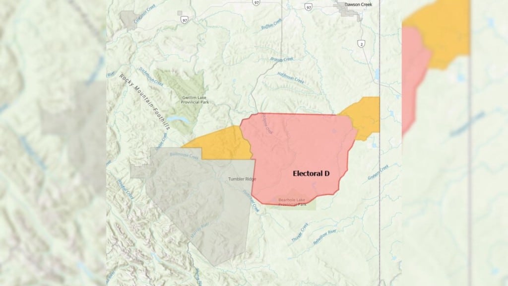
To determine if residents are under an evacuation order or alert, PRRD recommends using the online map tool.
Stay connected with local news
Make us your
home page
Authors

Related Articles

Dawson Creek officers appeal for missing teenager, 15
Ariel McDonald was reported missing on Thursday, April 2nd. She has not been seen since March 31st.

Fort St. John birthing centre closes for 24 hours due to ‘staffing shortage’
The birthing centre in Fort St. John will be closed until 8 a.m. on April 3rd due to “staffing shortages.”
Tickets sold out for Fort St. John’s 2026 Firefighters Charity Ball
Tickets for the 2026 Firefighters Charity ball are now sold out, according to the Fort St. John Firefighters Charitable Society.
