BCWS hands operational control of North Peace Complex to PG Fire Centre
The Prince George Fire Centre (PGFC) said Monday that the BC Wildfire Service (BCWS) is winding down the number of resources responding to fires in the North Peace Complex due to reduced wildfire activity.
FORT ST. JOHN, B.C. — The Prince George Fire Centre (PGFC) said Monday the BC Wildfire Service (BCWS) is winding down the number of resources responding to fires in the North Peace Complex due to reduced wildfire activity.
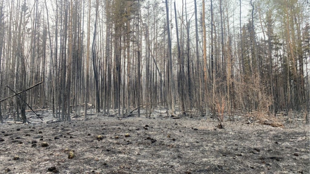
The North Peace Complex includes the Red Creek, Cameron River, Boundary Lake, and Stoddart Creek wildfires.
Fire information officer with the Prince George Fire Centre, Davin Richmond, said Monday the only fire in the complex receiving suppression activities is the Stoddart Creek wildfire, which is classified as being held and is currently estimated at 29,222 hectares.
On Monday, there are a total of 51 resources active on the Stoddart Creek Fire, with two unit crews, two initial attack crews and two helicopters responding. Structure protection personnel have been demobilized from the complex, and heavy equipment crews are transitioning from fire guard work to rehab work.
The Red Creek fire is currently estimated at 2,947 hectares, Cameron River is approximately 385 hectares, and Boundary Lake is about 6,171 hectares.
Richmond said those fires are classified as under control and are being monitored via helicopter.
“Helicopter resources associated with the North Peace complex have taken a downturn, but there is an operations branch manager that is flying around those fires, checking for any kind of increase in activity or hotspots. But all three of those fires are under control,” Richmond stated.
Latest Stories
Moving into the week, PGFC said it is expecting wind from the west, with potentially strong gusts in Fort St. John. The centre is also anticipating temperatures to slowly climb upwards in the next few days.
“Areas of unburnt fuels within the perimeter of any existing fires, not just those in the North Peace Complex, may still see increases in visible fire behaviour, including smoke, but the current forecast is not expected to challenge the perimeters,” Richmond said.
Fire crews responding to blazes in the Donnie Creek Complex saw some calmer days on Sunday and Monday compared to Saturday in regards to fire activity, according to fire information officer Bryan Zandberg.
“Saturday was very aggressive. We saw huge plums of smoke rising from various portions of the fire. The fire was finding fuels and making these isolated runs in the fuels. Saturday night, we had a cold front come through with really strong winds that blew the fire overnight further to the east,” Zandberg said.
He added while much of the area currently occupied by the Donnie Creek Complex is remote, there are a few cabins and some rail infrastructure in the east that BCWS is monitoring.
“The fire burned very close to industry camps and infrastructure and assets in that area. Saturday’s runs made us more aware of the fact that with the wrong winds, those assets and camps could be in harm’s way,” Zandberg stated,
Zandberg said the area received about one to two millimetres of rain and cooler temperatures on Sunday, as well as some cloud coverage which helped to calm fire activity.
He said Monday was similar, but crews could potentially see increased wildfire activity in the evening due to the 20-kilometre-per-hour winds from the west forecasted for the area.
On Monday afternoon, BCWS personnel conducted some planned ignitions in the southern part of the Donnie Creek fire in an attempt to get rid of problematic green forest fuels that are sitting against containment lines and are at risk of catching fire.
Zandberg explained if those fuels ignited organically, they would lead to the fire jumping a fire guard and spreading further.
“We like to do planned ignitions when weather conditions are really favourable and when we’ve got a really good burn plan in place. We tend to use this tactic in areas that are really critical for our operations,” Zandberg said, adding that burn plans will proceed throughout the week if winds are cooperative.
He said residents in the area may see some visible smoke from the Alaska Highway, but this is due to those planned ignitions.
Over the next 3-5 days, #BCWildfire Service will conduct planned ignitions on the Donnie Creek Wildfire (G80280) to better contain key areas of the fire. Smoke will be highly visible to the public from #BCHwy97 pic.twitter.com/dC2tEVEbZJ
— BC Wildfire Service (@BCGovFireInfo) May 29, 2023
While winds continue to come up from the south and from the west, Zandberg said they’re more stable and predictable than the winds previously experienced by personnel responding to the Donnie Creek fire.
“This fire really took a great big run prior to my team arriving here, but when it really blew up, it was driven by a very different set of winds—quite anomalous ones, I understand,” Zandberg stated.
Going into the week, Zandberg said surface fuels will continue to dry out after the large amount of rain in the region, which he said makes them able to easily carry fire.
He said there is no precipitation in the forecast, which will cause those fuels to dry out further, but BCWS is also anticipating cooler temperatures and cloud cover, which may prevent some solar radiation that could add more energy to the fire.
As of Monday, there are five helicopters, an incident management team, structure protection personnel, 77 fire suppression staff and 19 pieces of heavy equipment—which is being used by many local operators to help BCWS build containment lines.
The Donnie Creek wildfire is currently estimated at 157,500 hectares, while the Klua Lakes fire is at about 29,060 hectares.
The Muskwa River fire is now classified as being held and is approximately 8,856 hectares.
On Sunday evening, the Peace River Regional District issued a new evacuation order and alert for the Donnie Creek and Tommy Lakes wildfire, while the Northern Rockies Regional Municipality (NRRM) upgraded an evacuation alert to an order.
The NRRM released an updated map of the evacuation order area Monday afternoon.
* May 29th, 2023 1500 hrs. Map and boundaries updated to reflect correct area.
— NRRM (@NorthernRockies) May 29, 2023
⚠️ EVACUATION ORDER FOR THE KLUA LAKES AREA
May 28, 2023 at 1000 hrs
Pursuant to Section 12 (1) of the Emergency Program Act the current Evacuation Alert area is being elevated to an Evacuation Order pic.twitter.com/6vL7MNNDEo
For the latest evacuation order and alert information, visit the Peace River Regional District’s website.
For the latest wildfire information, visit BCWS’ website.
Stay connected with local news
Make us your
home page
Authors

Related Articles
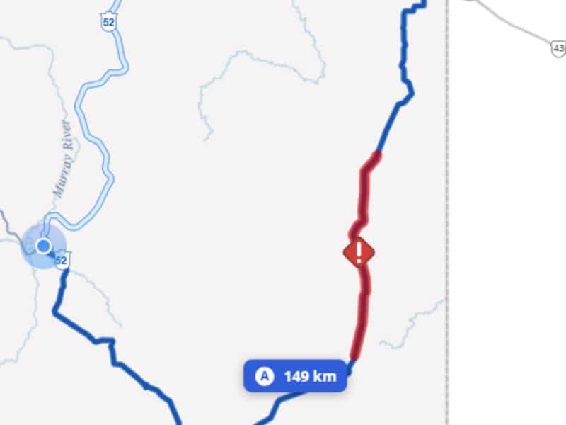
Single-lane traffic on Highway 52 due to wildfire
There will be single-lane alternating traffic daily from 7 a.m. to 9 p.m. on Highway 52 due to the Sunderman Creek wildfire.
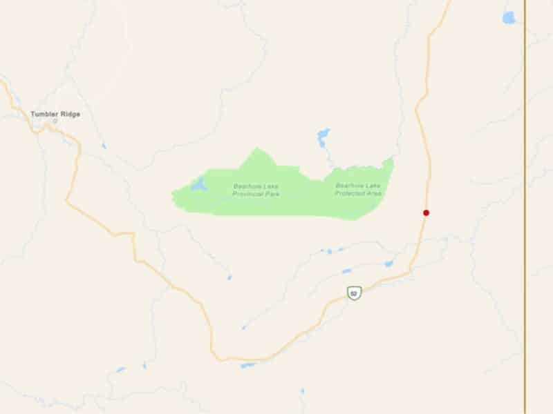
(UPDATE) Wildfire reported near Bearhole Lake Provincial Park
A wildfire has been reported near Bearhole Lake Provincial Park, adjacent to Highway 52.
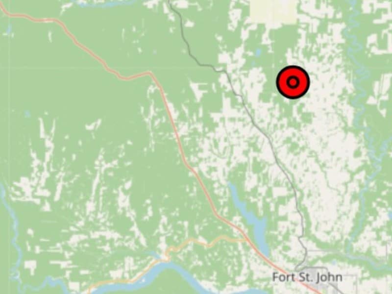
(UPDATE) BCWS fights wildfire north of Fort St. John
The one-hectare wildfire was reported during the afternoon of Wednesday, May 13th.
