Changes made to Donnie Creek wildfire evacuation alerts, orders
The Peace River Regional District has changed the size of the evacuation orders and alerts for the Donnie Creek wildfire.
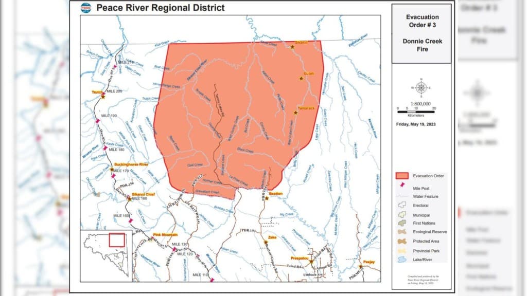
FORT ST. JOHN, B.C. — The Peace River Regional District (PRRD) has changed the size of the evacuation orders and alerts for the Donnie Creek wildfire.
The following areas are under an evacuation alert:
- Nig Creek and North of Nig Creek on the Beatton Airport Road,
- North of 24 km on Tommy Lakes Road,
- East of Highway 97 from Mile 120 to Trutch,
- Including all areas within 20 km of the Donnie Creek Evacuation Order Area.
Local News You Can Trust
Label us as a Preferred Source to see our stories more often
The following areas are under an evacuation order:
- North of the Beatton River on Tommy Lakes Road and the Beatton Airport Road,
- North of Grewatsch Creek on PDR 22,
- Extending North to the border with the Northern Rockies Regional Municipality.
The Donnie Creek wildfire combined with the West Conroy Creek, Hockey Creek and Katah Creek wildfires, and is now approximately 118,000 hectares.
For the latest information on alerts and orders in the PRRD, visit its website.
Latest Stories
Stay connected with local news
Make us your
home page
Authors

Related Articles

Fishing and Wildlife Compensation Program seeks new board member in region
The Fishing and Wildlife Compensation Program is dedicated to conserving and enhancing the lives of fish and wildlife in watersheds impacted by BC Hydro Dams
Provincial government announces 45,000 hectares of protected lands in northeast B.C. for the next decade
The new protected area – named the K’ih tsaa?dze Protection Area – overlaps with Doig River’s tribal park of the same name, which was first dedicated in 2011.

Taylor Public Library holds bottle drive fundraiser
The Taylor Public Library is hoping to raise funds through a bottle drive for its programming.
