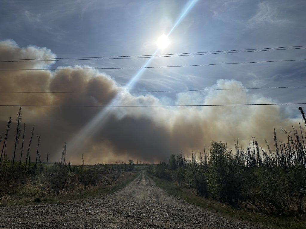
UPDATE – Stoddart Creek fire grows to over 3,000 hectares
The Stoddart Creek fire is over 3,000 hectares and with the expected shift in winds, the PRRD has expanded the area under an evacuation alert.
(UPDATED 5:50 p.m.) – This story has been updated to reflect the estimated fire size of 3,000 hectares and the new evacuation alert.
FORT ST. JOHN, B.C. – Stoddart Creek fire is over 3,000 hectares and the PRRD has expanded the evacuation alert to include Charlie Lake.
The fire that started Saturday afternoon near Mile 70 of the Alaska Highway has grown to over 3,000 hectares in less than 24 hours.
With the growth of the fire and the expected change in wind direction on Monday, the Peace River Regional District expanded the evacuation alert.
The new alert has been expanded to include:
• Pineview, Montney, North Pine, Rose Prairie, Murdale and northern sections of Charlie Lake.
The Stoddart Creek Evacuation Alert #2 total area now extends from Highway 97 to the Beatton River, including
Latest Stories
• areas north of Charlie Lake Provincial Park and the intersection Montney Road and Rose Prairie Road, and
• areas south of Buick Creek Road and Aitken Creek Road.
Thee Peace River Regional District has created an online map to show what properties are being evacuated and on alert. You can view the map by clicking here.

Fire activity expect to increase
On Sunday, the B.C. Wildfire Service had 31 firefighters and a heavy equipment task force that working on the north and south flanks of the fire to establish control lines.
Crews focused on holding these two flanks and will be supported by multiple helicopters throughout the day in order to do so.
With unseasonably hot and dry conditions, fire activity and behaviour is anticipated to maintain moderate rates of spread, vigorous ground fires and intermittent crowning into foliage.
Crews focused on strengthening containment in areas of the fire that may be challenged by the expected wind shift forecast for Monday into Tuesday.
Saturday night, the Peace River Regional District issued an evacuation order and an alert for residents. Anyone that is evacuated is asked to go to the North Peace Arena in Fort St. John for support. You can also call the ESS at 250 794-3310. If you need any evacuation support, you can contact the Peace River Regional District at 1-800-670-7773.
Peace River Regional District has created an online map to show what properties are being evacuated. You can view the map by clicking here.
The Evacuation Order is in effect for properties in the following area:
- North of 256 Rd, south of Blueberry River (272 Rd), east of Hwy 97 and Beatton Airport Rd, west of Prespatou Rd
Stay connected with local news
Make us your
home page
Authors

Related Articles
Woman and dog die in Alaska Highway crash
Northern Rockies RCMP have reported a single vehicle car crash on the Alaska Highway ended with a woman and her dog dying on June 11th.
Northern Health launches off-road vehicles survey in wake of Pouce Coupe crash
A Northern Health research team is conducting a survey on the use of off-road vehicles in northern B.C.
Fort St. John received two community leadership awards from NCLGA
The City of Fort St. John has received two awards from the North Central Local Government Association.
