BC Hydro shares Site C reservoir plan
The reason the Site C reservoir will begin being filled late in the summer and throughout the fall is to reduce its impact on local wildlife as much as possible, according to BC Hydro.
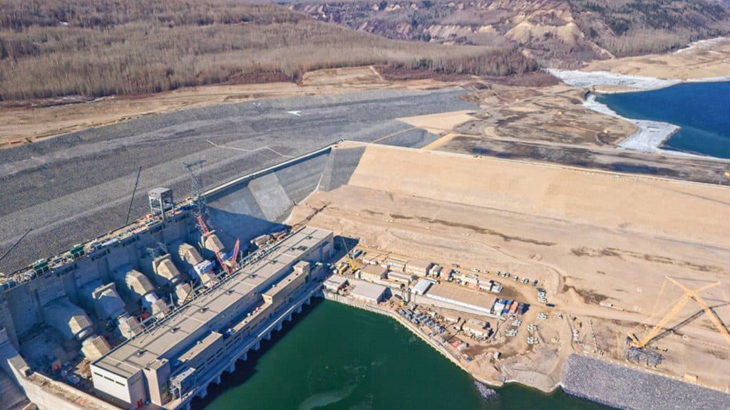
FORT ST. JOHN, B.C. — The reason the Site C reservoir will begin being filled late in the summer and throughout the fall is to reduce its impact on local wildlife as much as possible, according to BC Hydro.
The utility held meetings in Fort St. John and Hudson’s Hope earlier this month to share more information about the reservoir filling process with the public.
The process is expected to take four months, using water already stored in and released from the nearby Williston Reservoir. That means lower-than-average snowpack this year and ongoing drought conditions won’t impact the process.
Local News Straight
to Your Phone
Download our app today!
Available on Android and iOS devices
‘The volume of the Site C reservoir is many times smaller than the expected annual minimum flow releases from the Williston Reservoir,” the presentation reads.
“In an average year, water flowing into the Williston Reservoir can fill Site C up to 20 times. Even in another regional drought, similar to last year, the Williston Reservoir has over 10 times more generation discharge than the volume required to fill Site C.”
Once the reservoir is filled and Site C is operational, the daily average water level range is expected to increase in Taylor to 77 centimetres, up from the current average of 44 centimetres, according to BC Hydro.
The presentation also says the reservoir filling will cause shoreline erosion and slope instability, which could last for several years.
Latest Stories
“The impacts will vary around the shore, depending on the location,” the presentation reads. “As part of our public safety plan, we’ll communicate any hazards that may impact the public.”
A 2.6-kilometre berm has also been built along the shoreline in Hudson’s Hope to help protect that area from erosion. Other berms have also been erected along stretches of Highway 29.
“Incorporated into the [Hudson’s Hope] berm, we’re building a recreation site that can be accessed by vehicles seasonally and will also be connected by walking trails,” BC Hydro says.
“Public access to the recreation site is currently limited to ensure safety during construction. It will be closed during reservoir filling and until the reservoir is deemed safe.”
New boat launches at Halfway River and Lynx Creek, as well as a small craft launch at the D.A. Thomas Public Use Management Area, will also be created, although they won’t open until one year after the reservoir is filled so BC Hydro can ensure the sites are safe.
The current Halfway River boat launch is still accessible for now but will close permanently in mid-August. Meanwhile, the current launches at Lynx Creek and D.A. Thomas are inaccessible.
BC Hydro also says the reservoir filling is expected to temporarily increase the amount of mercury in Peace River fish as organic material from the surface gets permanently submerged underwater.
“Methylmercury levels in fish in the reservoir will initially rise as bacteria decompose organic material in newly submerged areas and convert inorganic mercury to methylmercury,” the presentation reads.
“Eventually, organic matter becomes scarce at the bottom of the reservoir. Methylmercury creation will slow down and levels will drop throughout the food chain.”
According to BC Hydro’s meeting presentation, the late-summer start date was chosen because it “will avoid the peak spring to early summer bird nesting and late fall and winter black bear hibernation seasons to reduce potential wildlife impacts.”
Other steps BC Hydro says it’s taking to protect the environment include building new habitat supports for animals like birds and bats, reclaiming and restoring wetlands with help from Ducks Unlimited, and building a passage facility to allow fish to move upstream unimpeded.
The reservoir, once filled, will cover 5,550 hectares of land and will be, on average, two to three times as wide as the current Peace River. It’ll also cause the mouths of Moberly River, Halfway River and Cache Creek to widen.
To view the full presentation, look below.
Stay connected with local news
Make us your
home page
Authors

Related Articles
Snowfall, ‘rapidly changing’ weather conditions expected Monday, says Environment Canada
Heavy snowfall is expected in Northern B.C. due to a frontal system coming in to start the week, according to a weather alert from Environment Canada.
City to host celebration of walking track sponsorship renewal
The City of Fort St. John is hosting an event to celebrate a renewed 15-year sponsorship licence for the walking track inside the Pomeroy Sport Centre.

Energeticcity.ca Weekly Review: Community Events Calendar
In this edition of the Weekly Review, get ready for our new Community Events Calendar. Plus, the most-read stories of the week.
