Evacuation Alert issued for Donnie Creek wildfire
The Peace River Regional District (PRRD) issued an evacuation alert for the Donnie Creek wildfire area.
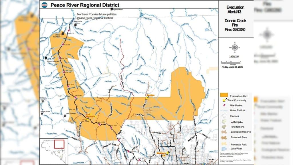
FORT ST. JOHN, B.C. — The Peace River Regional District (PRRD) issued an evacuation alert for the Donnie Creek wildfire area.
Due to the potential risk to life and health, residents have been asked to take the necessary steps to prepare for possible evacuation from the following areas:
- From Mile 207 on Highway 97 Northwest to the Prophet River
- Southwest following the Prophet River for 14 kilometres to Milliken Creek
- From that point, continuing southeast, maintaining approximately a 6-kilometre buffer west of Highway 97 North to the point of intersection of kilometre 20 on the Pink Mountain Road (Halfway River)
- Southeast following Halfway River to the intersection of Boring Ranch Road and Cypress Creek Road.
- Southeast and east to the point of intersection with Highway 97 North at kilometre 177
- Heading north along Highway 97 to 1 kilometre north of Tommy Lakes Road
- Turning northeast within 1 kilometre of the Tommy Lakes Road for 20 kilometres
- From there, heading due east to 3 kilometres east of PDR 200 (North of Peejay)
- North to the headwaters and including the following creeks: West Milligan Creek, Big Arrow Creek, and Zaremba Creek
- South to a point 16 kilometres due east of the intersection of the Black Creek and Beatton River
- Heading due west towards a point 6 kilometres before mile 160 on the Alaska Highway
- Turning northeast along the Sikanni Chief River for 4 kilometres
- Heading northwest for 44 kilometres
- Then southeast towards Kirkpatrick Creek
- Then generally northeast towards Horse Range Creek
- Then northwest to Mile 207 to the Prophet River

The alert was issued to prepare residents to evacuate their property should the need arise.
Residents will be given as much advance notice as possible before evacuation.
For more information on evacuation alerts and orders, visit PRRD’s website.
Latest Stories
The Donnie Creek wildfire is approximately 571,512 hectares and is still classified as out of control.
The latest information on wildfires can be found on BC Wildfire Service’s website.
Stay connected with local news
Make us your
home page
Authors

Related Articles

Kiara Agnew’s family ‘grateful and thankful’ for protest support to demand action on guilty verdict
Family and supporters of Kiara Agnew protested in Fort St. John on February 8th against the freedom of Ryan Friesen, who was found guilty earlier this year of the Dawson Creek woman’s femicide in Mexico in 2023.
Community plan shows ‘coordinated, efficient long-term planning,’ First Nation says
Fort Nelson First Nation held a community engagement meeting about its Reaching For Our Vision (RFOV) plan and Four Pillars Plan in February 2026.

UNBC to offer new nursing pathway for licensed practical nurses
The University of Northern British Columbia (UNBC) program is designed for practicing licensed practical nurses, and is intended to provide them with a faster route to becoming registered nurses.
