New evacuation orders and alerts issued for Donnie Creek wildifre
The Peace River Regional District has issued an evacuation order and a new evacuation alert for properties near the Donnie Creek
UPDATE – The Peace River Regional District has issued two evacuation orders and alerts for the Donnie Creek wildfire. This story has been updated to reflect this.
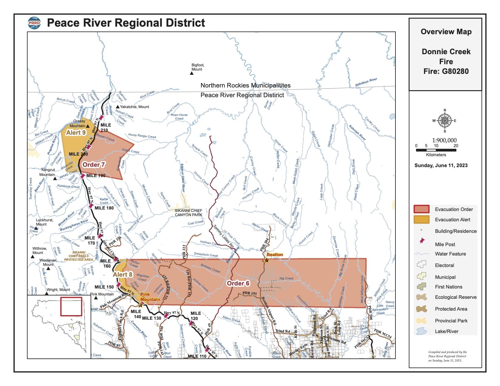
FORT ST. JOHN, B.C. – The Peace River Regional District has issued two new evacuation orders and two new evacuation alerts for properties near the Donnie Creek/Tommy Lakes wildfire.
On Sunday, the region experienced strong northwesterly winds. This caused aggressive fire behaviour and growth in the southern part of the fire. The Wildfire Service will be deploying structure protection units to the area. The Donnie Creek wildfire is over 404,916 hectares and is considered one of the largest wildfires in B.C. history. The fire is approximately 136 km southeast of Fort Nelson and 158 km north of Fort St. John.
Local News Straight
to Your Phone
Download our app today!
Available on Android and iOS devices
Donnie Creek/Tommy Lakes Evacuation Order #6 applies to properties that were previously under Evacuation Alert #7, including the following areas:
- 4 km east of Highway 97N between Sikanni Chief and Pink Mountain;
- due east from Pink Mountain to a point where it intersects with West Milligan Creek;
- due North 24 kms; and
- west to point of intersection (Sikanni Chief 4 km east of Highway 97).
The second evacuation order (evacuation #8) is closer to the Alaska Highway and covers the following area:
- east of Highway 97N between Mile 192 and Mile 207; and
Latest Stories
- between Pink Mountain and Sikanni Chief, 1 to 4 km east of Highway 97.
The following area remains under evacuation alert #8:
- extending East 20 km of Highway 97N
Evacuation alert #9 was also issued late Sunday and includes the following area:
- west of Highway 97 N between Mile 192 and Mile 207;
- west 6 km from Mile 192 of Hwy 97N;
- from that point, north to the Prophet River; and
- east following along the Prophet River for 14 km then southeast to Mile 207 of Hwy 97N.
This does not apply to First Nations communities or municipalities, as they issue their own orders and alerts.
Anyone evacuating should head to Fort St. John and the Pomeroy Sport Centre. The Emergency Support Services Centre will be open from 10 a.m. to 2 p.m. on June 12, 2023. You can also register by phone at 250-794-3310.
Stay connected with local news
Make us your
home page
Authors

Related Articles

Northern Health warns of two new measles exposures in Fort St. John
Northern Health is warning residents in Fort St. John of two potential measles exposures on March 17th.
Applications open for Tumbler Ridge Scholarship Program
The District of Tumbler is asking for applications for its 2026 scholarship program. The deadline to apply is May 15th.

Peace Fibre Fest to return in 2026 for yarn enthusiasts
The Peace Fibre Fest began in 2019 when its founders wanted to being a yarn arts extravaganza to the Peace region.
